Phrygian Way
where Alexander the Great cut the legendary Gordian Knot
Phrygian Way ( Frig Yolu in Turkish ) is a trail network that winds its way through
the Phrygian Highlands of Western Turkey for a total of 506 kilometers.
What makes Phrygia so unique is the magnificent landscapes formed by ancient lava fields
and carved by wind and water to form strange spires of rock, countless caves, and strange
castle like towers.
The region takes its name from the Phrygian people who, over 3000
years ago began to carve the soft volcanic stone into temples and monuments.
From their capital city of Gordium, where Alexander the Great cut the legendary Gordian Knot
Phrygian culture and art spread through what is now western Turkey.
Surprisingly little is known about the Phrygian people apart from their place in legends
such as King Midas with his golden touch, or the wars of the Phrygians with the Amazonians.
Between the mystical geography and the history carved into the landscape the Phrygian Way offers an amazing and unique hiking experience.
Trust us
you won't regret it


Midas Monument in Phrygian
The Rock of the Forty Eyes
Midas Monument
Phrygian Civilization
The Heart Of Turkey
The Phrygian Valley which is spread over a region within the borders of Eskisehir, Kütahya, and Afyon provinces today is home to historical ruins and ancient artifacts bearing traces of the Phrygian civilization.
The Phrygians are peoples who migrated into Anatolia from the Balkans, where they first appeared on the stage of history circa 12th century BCE in Thrace.
With this movement, they have been the source of many mythological stories ever since.
the Phrygian Valley is a nature park that passes through 7 provinces and countless
counties it has a total area of 55 hectares.
The most beautiful aspect of the valley is that, as it is still a mostly undiscovered route, it offers visitors
the opportunity to be alone with nature and awe inspiring history at the same time.
Many say that the booming Phrygian Valley will become the 2nd Cappadocia.
Phrygia was divided into two regions in the ancient times.
Phrygia Megale : covering the area between Red River in the east, Lidia region in the west
Lakonya in the south and Köroglu Mountains in the north.
Phrygia Micra : or “Phrygia Epiktetus” the region covering the provinces of Eskisehir, Afyonkarahisar
and Kütahya today.
The latter is also called Mountainous Phrygia as it is an upland mountainous area which is constituted
by deep valleys and volcanic tuff rocks.
Phrygians settled their sacred places and cult centers in such highland areas as they believed Goddess
Kybele appears in bare cliffs, valleys and mountains near to freshwater bodies.
As a result, it is the Mountainous Phrygia region, which encompasses nearly 52 Hectares.
where the Phrygians had their most powerful political and cultural dominance throughout their history.
Collapsing :
The Phrygian State collapsed in the early 7th century BC following the attacks of nomadic Cimmerians who sacked the whole Anatolia. However, they were not completely erased from the world history.
The members of the royal family, who were able to survive the Cimmerian attacks, continued their existence in various parts of Anatolia, conserving their culture and traditions.
The Phrygian principalities lived in the Mountainous Phrygian Region independently until the Kızılırmak (Halys River) expedition of the Lydian King Alyattes to the Medes in 590 BC.
Then, until the Persian occupation in 547 BC, they survived as principalities subsumed to the Lydian Empire.
In 547 BC, the Lydian Empire collapsed when the Persian King Cyrus II conquered Sardis (today known as Sart/Salihli), the capital of the Lydian King Croesus. Following this event, Phrygia was a part of the Persian Empire for over two centuries.
What Was the Gordian Knot?
Gordian knot knot that gave its name to a proverbial term for a problem solvable only by bold action.
In 333 bc, Alexander the Great, on his march through Anatolia, reached Gordium, the capital of Phrygia.
There he was shown the chariot of the ancient founder of the city, Gordius, with its yoke lashed to the pole by means of an intricate knot with its end hidden.
According to tradition, this knot was to be untied only by the future conqueror of Asia. In the popular account, probably invented as appropriate to an impetuous warrior, Alexander sliced through the knot with his sword, but, in earlier versions, he found the ends either by cutting into the knot or by drawing out the pole. The phrase “cutting the Gordian knot” has thus come to denote a bold solution to a complicated problem.
In Midas’s hands everything turned to gold :
The fabulous wealth of Phrygian kings, among whom the names of Gordias and Midas were apparently common over several generations, has been preserved in the legend of king Midas, in whose hands everything turned to gold.
When Midas bathed in the Pactolus River ( today Sart Çayı ), he transferred this gift to the river, thereby turning the Pactolus into the richest gold carrying river and the kings of Sardis on its banks into the wealthiest rulers of Asia Minor at the time.
According to Herodotus, even the Egyptians considered Phrygians to be the most ancient people:
Legends :
A poor farmer from Macedonia, Gordias was the first king of the Phrygians. For this reason, their capital city near Ankara was named Gordion.
You may remember this name from the mythical Gordian Knot.
Giving rise to the Alexander Great legend, the Gordian knot was tied by the Phrygian king Gordias only to be sliced in half with Alexander's sword.
Nonetheless, his son Midas was the Phrygian king who had a more fantastic reputation.
One of the myths emerging from Anatolian lands is King Midas and his ears. According to the legend, Apollo, the god of music, arts, the sun, fire, and poetry, competes with Pan, the god of the wild, shepherds, and flocks. Apollo has his silver, and Pan has his flute.
And Midas is on the jury. The sound of Apollo's lyre fascinates everyone. At the end of the competition, all judges favor Apollo, but when Midas votes for Pan, Apollo turns Midas' ears into donkey ears.
However, King Midas is most famously remembered in mythology for his ability to turn everything he touched into gold.
Apparently, he prayed for this. But according to legend, once he got his wish, Midas died of starvation due to his "vain prayer" for the gold touch.
In time, this came to be called the Midas touch.


Phrygian Valley
Byzantine church in Ayazini
Ayazini cave church
rock tombs
A Structure in Phrygia valley
The Inscriptions of Gordion


Highlights :
Yazılıkaya :
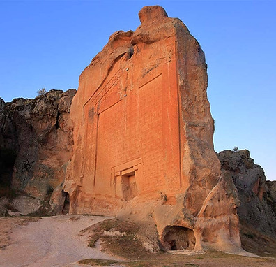
At the heart of The Phrygian Way, where its three branches meet, is the village of Yazılıkaya.
Yazılıkaya, meaning inscribed rock takes its name from the spectacular monuments in the ancient settlement known as Midas City, named after King Midas of the Golden Touch.
With massive monuments, cisterns, altars, and tombs Yazılıkaya really captures the spirit of what makes the ruins of ancient Phrygia so special.
Seydiler Village and Kırkinler :
While not right on the trail itself, the village of Seydiler sits just a kilometer away from the trail head itself (south-eastern route).
The village is dominated by a tall bank of chalky white dust with spires of rock and fairy chimneys rising dramatically from the bank.
Further up the hill behind the village there are numerous fairy chimneys and cones of pale volcanic stone.
Just outside of the village of Seydiler is a cave filled rock formation called Kırkinler, meaning ‘Forty Dens’.
Carved into the tower of stone is a stunning monastic complex consisting of sprawling vaulted chambers decorated with numerous crosses carved in different styles and sizes on walls and ceilings.
Ancient Roadways :
Throughout the lands of the Phrygians you can find cart tracks that have worn deep ruts into the soft volcanic stone. In some places these ruts were carved out into narrow canyon like roadways.
Gordion Ruins :
Also known as Gordium this site having been inhabited for 4,500 years, reached a zenith around 600 BC as the capital of the Phrygian civilization.
The site consists of the ancient city mound and numerous tumuli (burial mounds); the best known of which being the tomb of the Phrygian’s most legendary ruler : King Midas.
This site marks the far North-Eastern start of the trail, cutting through terrain that is mostly flat and tilled compared to the forested hills of the southern and western portions of the trail.
Ayazini Rock Church :
The Ayazini rock church is the main highlight of the ruins of ancient Ayazini, a settlment dating as far back as the Phrygian period.
The area around the village of Ayazini is home to a Byzantine era rock cut church, rock spires, and numerous tombs. Today’s village only occupies a small portion of the ancient city.
The fairy chimneys and rock cut tombs blend with the modern homes making for an absolutely fascinating atmosphere.
Just outside of the village is the cave filled rock formation known as Avdalaz Castle.
Aslantas and Yılantas :
The Göynüs Valley ( sometimes written Köhnüs ) is thought to have been a sacred place to the Phrygians and is home to the largest Phrygian Necropolis found to date.
The Aslantas tomb is impressive and the nearby Yılantas though heavily damaged, is worth seeing.
Aslantas meaning ‘lion rock’ is a monument with a pair of rearing lions carved over a small opening in the rock.
Confusingly, Yılantas, meaning ‘Snake rock’ is also a rock monument of a lion.
The Yılantas monument is said to have once had a great snake carved into it though today all that’s left is the head of a lion.
Across from them is the Göynüs Castle, a great block of stone resembling swiss cheese with all its hollows that have been carved into it.
This particular valley is full of interesting rock formations and picturesque green meadows.
Arslankaya :
Meaning Lion Rock, this is a monument cut from a single block of stone with a niche at the bottom likely for the idol of the goddess Cybele, chief god of the Phrygians.
A pair of rearing lions carved into the rock spire, above the niche give the place its name.

Stone formation


Trailhead :
South Trailhead ( Seydiler )
The southernmost trailhead is in the province of Afyon. While Afyon doesn’t have an airport, it’s regularly serviced by buses from Istanbul, Ankara, and Antalya. From the Afyon city centre you can take a minibus (leaving from next to the Park Afyon mall). The trail begins at the turnoff for the village of Karakaya, though you may want to get off in Seydiler where you can start your trip by exploring some fairy chimneys and other unique rock formations or the Kırkinler rock caves another 2 km up the road past Seydiler.
West Trailhead ( Yeniçiftligi )
The west trailhead is about halfway between the cities of Eskişehir and Kütahya in a place marked as Yeniçiftliği, though you won’t find anything by that name on google maps. There is a sign board marking the trail head on the east side of the road (D230 aka Eskişehir-Kütahya highway) near the western end of the Porsuk Baraj lake, just west of the Frig Vadisi road. Bus trafic bewteen Eskişehir and Kütahya is frequent, just make sure that whatever bus you use is willing to let you out along the road.
Eskişehir is serviced by highspeed train along the Istanbul-Ankara route, and both Istanbul and Ankara have major airports.
East Trailhead ( Gordium )
The east trailhead can be found in the village of Yassıhöyük, the site of the ruined capital of the Phrygians. Yassıhöyük village is 18 kms outside of the sizable town of Polat from which you can take a minibus or taxi to the trailhead. Polat is regularly serviced by bus from Ankara and sits along the above-mentioned highspeed train route between Istanbul and Ankara, both of which have international airports.